
· today in space history · 3 min read
The Day That Changed How We Navigate Forever
Forty-seven years ago, an Atlas rocket carried the first GPS satellite into orbit, launching a revolution in navigation that would transform daily life across the globe
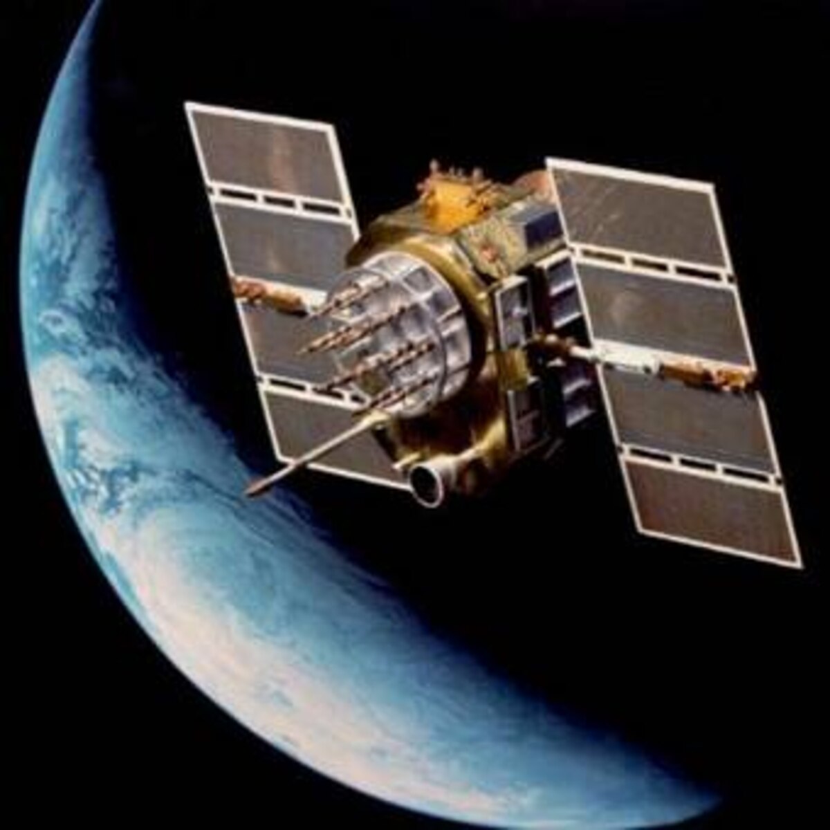
On a clear winter night in 1978, an Atlas F rocket thundered into the darkened skies above Vandenberg Air Force Base in California. In its payload bay sat a 759-kilogram satellite that would transform human civilization’s relationship with navigation and timekeeping. At precisely 23:44 GMT on February 22, Navstar 1, the first Global Positioning System satellite, began its journey to an orbit 20,200 kilometers above Earth.
A Vision of Global Navigation
The launch of Navstar 1 represented the culmination of years of military research and development into satellite-based navigation. The U.S. Air Force had recognized the potential for a constellation of satellites to provide precise positioning information anywhere on Earth. This first satellite would prove whether such a system was technically feasible and reliable enough for military operations.
Breaking New Ground
Navstar 1 was a technological marvel for its time. As part of the “Block I” series of GPS satellites, it carried multiple atomic clocks and sophisticated radio transmitters designed to broadcast precise timing signals. These signals would allow receivers on the ground to calculate their exact position by measuring the time it took for signals to arrive from multiple satellites. The concept was elegant in theory but required unprecedented precision in both timing and orbital positioning to work in practice.
The Launch That Changed Everything
The Atlas F rocket, modified with an SGS-1 upper stage, performed flawlessly during the critical launch phase. After a series of precise burns, it placed Navstar 1 into a medium Earth orbit at an inclination of approximately 64.5 degrees. This carefully chosen orbit allowed the satellite to maintain consistent coverage over large portions of Earth’s surface while ensuring stable operations of its sensitive atomic clocks.
From Military Asset to Global Utility
Once in orbit, Navstar 1 began its technology demonstration mission. Engineers and technicians worked to verify the satellite’s systems and validate its navigation signals. By March 31, 1978, the satellite was declared operational, proving that precise satellite-based navigation was possible. This success paved the way for additional launches that would eventually create the full GPS constellation.
A Revolution in Precision
The impact of Navstar 1’s success extended far beyond military applications. While the original goal was to provide precise navigation for military operations, the system’s potential for civilian use became increasingly apparent. The technology that began with this single satellite would eventually enable:
- Turn-by-turn navigation in personal vehicles
- Precision timing for global financial transactions
- Synchronization of cellular networks
- Accurate tracking of shipping containers worldwide
- Precision agriculture and land surveying
- Emergency response coordination
Legacy and Modern Impact
Today, GPS technology has become so integrated into daily life that it’s easy to forget it all began with a single launch in 1978. The system that Navstar 1 pioneered has inspired similar networks worldwide, including Russia’s GLONASS, Europe’s Galileo, and China’s BeiDou. These systems collectively provide the positioning and timing backbone for modern global infrastructure.
Looking Forward
As we mark forty-seven years since that pivotal launch, the future of satellite navigation continues to evolve. Modern GPS satellites are far more sophisticated than Navstar 1, offering improved accuracy, additional signals, and better resistance to interference. Yet they all build upon the fundamental principles proven by that first satellite. From autonomous vehicles to space exploration, the technology that began with Navstar 1 continues to enable new innovations, reminding us how a single launch can transform human civilization in ways its creators could hardly have imagined.

Theodore Kruczek